Dig the Castle – Community excavation
The Council for British Archaeology:
🎉 Announcing the winner of the Community Archaeology Project of the Year Award! 🎉
Congratulations to the Dig the Castle Project! 🏰🔍
This fantastic project explored Torrington’s motte and bailey castle, engaging over 100 adults and 150 children in excavation and educational activities. The community came together to learn new skills, such as excavation and finds processing, while forming new friendships and enhancing their sense of well-being and purpose.
Thank you to everyone involved for making this project a resounding success! 🏆👏
Find out more about their work here 👉 https://www.archaeologyuk.org/…/celebrating-excellence…
#MarshArchaeologyAwards #CommunityArchaeology #DigTheCastle #Heritage.
Emily, John and the team are amazed, immensely proud and humbled to have been selected for these awards.
The ‘Dig the Castle’ project has now completed its ‘digging’ phase.
The dig has finished, the turf returned to the trenches and we are claiming some time out to top up some sleep!
Archaeologists Engage, Gt Torrington Futures Group and the team would like to thank the local community for its help, encouragement and support throughout the recent months. This project was put in place for two reasons, to engage the community in this unusual activity, and to strengthen the towns knowledge about its heritage and especially it’s castle. We feel we have managed to do all of those things, and along the way confirmed the utterly amazing spirit of community help that this wonderful town instils.
THANKYOU.
When the finds have been collated and recorded professionally, and the necessary reports written, we plan to have an open event in town to display some of the artefacts found and relay the reports information about the site. This event may be some way away, so please keep an eye out in The Crier and through our Facebook and Instagram pages (which you are welcome to follow) digthecastle
Information and images from the dig period will continue to be uploaded over coming months.
The whole project information then being placed in the towns Heritage Museum for all to view.
As an aside, the Museum really needs all of our support – both financially and as volunteers to help open the space. If you believe that heritage and history makes an impact on people and place, please consider joining the volunteers who have done so much to refresh and rebuild the museum and help take it to the next level!
Contact chair@torringtonmuseum.org.uk
With grateful support from:
THIS PROJECT COULD NOT HAVE HAPPENDED WITHOUT THE SUPPORT, FINANCIAL OR IN KIND FROM THESE WONDERFUL PEOPLE.
Archaeologists Engage
Torridge District Council ( 106 Grant / In kind help)
Great Torrington Town Council
Great Torrington Town Lands Charity
Great Torrington Commons Conservators
Great Torrington Heritage Museum
Great Torrington Chamber of Trade
Great Torrington Futures Group
Great Torrington Cavaliers
Great Torrington Rotary Club
Torridge District Councillors – Cllr Cottle–Hunkin, Cllr Bright,
Cllr Brown. Cllr Craigie
Devon County Council – Cllr Saywell
Tamar Trading
D.Scott Financial.co.uk
L J Developments
R.G.B. Building Supplies
Tesco XTRA, Barnstaple
Duffys Hardware,
Glenn and Della Bealey – Week Farm
GREAT TORRINGTON CASTLE: COMMUNITY DIG – OVERVIEW
Dates:
Frid 22 September – Sun 8 October 2023
Part of ‘Torrington Through Time’ Project
Great Torrington has had a chequered interest in the towns ‘Castle’ over the years.
Long known about, but with no acknowledgment of its existence on or around the remaining structure. With little information being available concerning its actual shape, size and layout, a project is underway which hopes to uncover much of the hidden heritage of the castle site, through a proposed dig in 2023.
Torrington Castle was the seat of one of Devon’s great Norman Baronies, so deserves to be put back on the map!
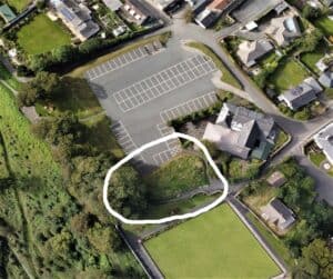
The motte mound and sections of the ramparts, on the edge of the Commons, survived largely intact but unacknowledged until the mid-20th century, when the site was infilled and converted into a car park by the County Council. The recent Historic England archive of aerial photography, made available online has highlighted how much erosion of the site has occurred since the 1930s and these images have highlighted the urgency to investigate, understand and hopefully then protect the castle for the community moving forward. The site remains unprotected to this day, not scheduled, like the many small similar motte and baileys in the surrounding landscape. Whilst it may no longer meet the strict criteria of designation, the excavation will help obtain further information about the history of castle and town.
This castle is also unique! It is the only one in Britain that sits on common ground which is ‘owned’ by the people of the town (G.T Commons Conservators) – all the rest are claimed by heritage organisations, private individuals or councils already – that makes this special.
This has also meant that Torrington, once the seat of one of Devon great medieval Baronies is not often included in the studies on castles in the county.
Previously there have been a series of small commercially led excavations in the proximity of the castle; for example in 1987 when the pavilion was installed on the bowling green site; these excavations uncovered evidence of stone buildings, floor surfaces and pottery from the 12th to the 15th centuries. The shallow overburden of soil and good preservation of the archaeology found suggests promising opportunities may lie ahead for the community in exploring the wider site.
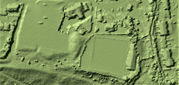
The physical survey of the earthworks which surround the car park and the remnants of the motte mound, as well as GPS and Lidar studies were undertaken March-August 2022 by Torrington Through Time (GT Futures Group and Archaeologists Engage).
The report can be found at this LINK (TTT21 REPORT)
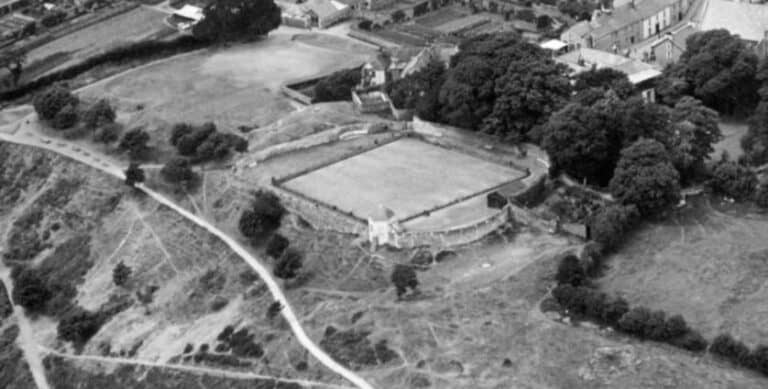
1937 Historic England Aerial Images Archive (showing the outer bailey under the bowling green, motte mound behind and inner bailey, now the car park). (copywrite Historic England – all images here)
FOR MORE PHOTOS FROM THIS ARIEL SURVEY FROM 1937 USE THIS LINK
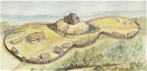
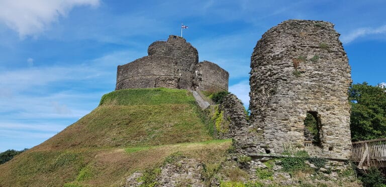
Below – Launceston’s motte and bailey castle, which survives largely intact, is likely to have been very similar to how the later castles looked in Torrington.
Image J.Eeles
A Little History………
This hilltop has been settled for thousands of years but it is first recorded as a town in Saxon times. Not long after the Norman invasion, a motte and bailey castle was constructed on top of the most defensible part of the Saxon town, making a powerful statement about control.
Burnt in the civil war, known as the Anarchy in the 12th century and pulled down by royal decree in the 13th century due to an early planning dispute, the castle, formerly of timber and earthen banks was rebuilt in stone in the 14th century and survived until the Tudor period.
The ruined castle, was briefly reused during English Civil War of the 1640s, the small surviving chapel onsite was reused as a school until the 1800s. The motte mound was included in the gardens of the adjacent grand house, it’s outer bailey, to the east reworked as a pleasure grounds and later a bowling green, the inner bailey became an orchard, now the car park. The name Barley Grove, is believed to represent a social memory of the castle and is a corruption of ‘Bailey’.
The Commons, in Torrington were given to the people of the town in the 1100s by the Lord of the Manor and comprise 365 acres, confirmed by the 1889 Parliamentary Act. The site of the ruined castle being just on the edge of the commons it was also transferred by the law. Uniquely, then, for a defensive statement of ruling power over the locals, Torrington Castle is in fact wholly owned by the people of the town, administered via the hardworking Commons Conservators committee.
Links to further reading and information: